Category guide · Last updated July 30, 2026
Route planning software for oil and gas
Not the shortest route. The most profitable one. Most routing products an operator will be shown were built for a fleet delivering interchangeable things to interchangeable places, and they optimize miles beautifully. A producing field is not that problem. What follows: what oilfield route planning has to solve, the constraints generic tools miss, how dispatch decisions get made, and five questions to ask any vendor.
The definition
What route planning means in oilfield operations
Route planning in oil and gas is the daily allocation of the scarcest resource in field operations: crew-hours. A lease operator, pumper, or gauger is responsible for somewhere between 30 and 300 producing assets and has one shift to spend on them. The software decides which of those assets get a visit today, in what order, and by which crew.
Most operators run an inherited loop: a route drawn by a previous superintendent, driven the same way every Monday, Wednesday, and Friday. It survives because it is fair, predictable, and easy to staff. It leaks because it treats the well running clean and the well quietly dying as equal stops, forever. The obvious upgrade looks like mapping software: minimize the miles, hand the crew a tighter loop. The fuel math improves and the blind spot does not move, because the most efficient possible tour of low-value stops is still a day spent on low-value stops.
Why this is not a delivery problem
Delivery routing is a solved, well-engineered field, and the math behind it is excellent. It rests on one assumption that quietly does all the work: every stop is worth about the same. When that holds, the value of the day is fixed the moment the stop list exists and the only remaining variable is cost. So you minimize distance, and you are right to.
On a producing field the assumption fails by orders of magnitude. A failing pump on a high-rate producer and a routine gauge on a stripper well appear on the same morning list, and one is worth a multiple of the entire rest of the route. The value of the day is not fixed by the stop list, it is determined by which stops make the list. Distance is the second-order term.
That is the difference between distance and value density: dollars of production impact captured per crew-hour spent. A plan built on value density will sometimes drive further to reach a well worth reaching, and will more often skip three nearby stops that earn nothing today. The net effect still runs the direction people expect: 35% fewer miles driven at equal economic coverage, measured across 5,000+ wells in live deployments.
The consequence for an evaluation is blunt. A tool that minimizes miles first is optimizing the wrong number, and no amount of oilfield terminology layered on top changes the objective function underneath. Are your best people working on your most valuable work today? A router cannot answer that. It was never asked to.
The constraint reality
Six constraints generic routing tools miss.
Objective function aside, the feasible region is different too. An oilfield route is shaped by constraints with no analogue in a delivery network, and a plan that violates one gets rewritten in the truck.
Crew qualifications and certifications
A stop is not assignable to whoever is nearest. H2S-certified crews belong on sour wells, pressure-vessel inspectors on PV assets, and an electrical isolation waits for the person carrying the card. Qualifications belong inside the solver, not in a warning printed after the plan is built.
Hours of service and the shape of the shift
Shift length, mandatory breaks, travel from the yard, and the drive home consume the day before a single well is worked. Plans that ignore them get quietly re-cut in the truck, which means the ranking never reached the field.
Lease roads, gates, and access windows
Public road networks stop at the lease line. From there the day runs on caliche, cattle guards, locked gates, and surface-owner windows no commercial map layer has seen. Two wells a mile apart on the map can be forty minutes apart on the ground.
Escort, buddy, and H2S requirements
Sour service, confined space, and hot work cannot be done alone, which turns one stop into a synchronization problem across two crew calendars. Lone-worker exposure is the safety side of the same constraint: fewer, better-justified visits is a routing outcome, not a policy poster.
Equipment co-routing and synchronization joins
A rod-pump job needs a pulling unit on location when the crew arrives. A paraffin cut needs the hot oil truck. These are joins, not stops: two resources have to meet at one place inside one window, and an error in either leg wastes both.
Weather and seasonal access
Freeze-offs, spring thaw, and a wet caliche road change which locations are reachable and which work is worth doing today. In most basins this is not an exception to the plan, it is a recurring re-plan trigger.
And six classes of work competing for the same shift.
- 01Scheduled equipment maintenance
- 02Reactive failure response
- 03Regulatory inspections under hard deadlines
- 04Risk-based proactive visits
- 05Liquid management: oil hauling, water hauling, tank reconciliation
- 06Routine information collection and gauging
These classes interact, which is what makes the problem genuinely hard rather than merely large. A hauler dispatched late induces a shut-in. An electrician routed first lets a workover proceed. An inspection missed by an hour erases a month of capture credit. The formal treatment, a multi-class vehicle routing problem with synchronization constraints and the solver built for it, is in the 40-page research white paper on optimal route planning. Class 02, reactive failure response, is the one most operations already generate automatically, from a SCADA threshold breach. Where those flags come from and why they arrive unranked explains why a routing solver fed by an unpriced queue optimizes the wrong stops efficiently.
Dispatch
Who assigns the work, and why dispatch by geography fails
On most producing assets, dispatch is a person. A superintendent looks at overnight SCADA, the callout list, the open work orders, and their own memory of which wells have been acting up, then allocates crews by area. It has worked for decades, and the people doing it are usually the most knowledgeable operators in the company. That is exactly the problem: the logic lives in one head, runs at the speed of a phone tree, and retires when they do.
Geographic dispatch fails in a way that is easy to miss because it looks like efficiency. Sending the nearest crew to the nearest work reliably produces a full, busy, low-mileage day, and it reliably fills that day with cheap stops, because proximity and value are uncorrelated. The well that started failing at 2 AM sits on the far side of the asset and waits. Nothing in the dispatch loop surfaces what that wait cost, which is why the loss is invisible in every report the operator runs.
Operators searching for oil and gas dispatch software, oilfield dispatching software, or work order dispatch software are usually trying to fix the visibility half: the whiteboard into a system, the assignment onto a phone, completion back. Worth doing, and where most of this market stops. It leaves the allocation decision exactly where it was. The operating model that moves the allocation decision, dispatching against sensor signal instead of a standing loop, is routeless operations.
What a ranked dispatch looks like
A ranked dispatch runs the decision before anyone logs in. Overnight, every asset is compared against its own learned normal, deviations are scored in dollars at risk, and candidate work is written as work orders automatically. The scored list is filtered by qualification, constrained by hours, access, and equipment, then sequenced into a route per crew. By the start of shift each crew has a plan in the cab with the reasoning attached: why this well, why this order, what to look for. The superintendent does not disappear from that loop and should not. Their job moves from building the day to auditing it, and every override feeds back as signal.
The same structure applies wherever a field workforce serves a network of dispersed assets, which is why gas utility dispatch and midstream field dispatch run on the same engine with a different scoring model. Those adaptations live in the use cases by vertical, and the work-generation layer underneath is oilfield work management.
The evaluation
How to evaluate route planning software
This category is dominated by horizontal fleet-routing platforms, delivery-optimization tools, telematics-first providers, and generic field service management suites, most of which have added an oil and gas landing page. Several are excellent at what they were built for. Five questions separate that from what a producing field needs.
Ask what the objective function actually is
Tools built for delivery and service fleets typically optimize miles, drive time, or stops completed, and they optimize those well: the routing math in that market is mature. The ceiling is that all three assume stops are worth roughly the same. Ask the vendor to state the objective in one sentence. If it contains distance and not dollars, you get the cheapest possible tour of a list nobody scored.
Ask where the stop list comes from
Routing and deciding are separate problems, and most of this market solves only the second. Generic field service management tends to assume the work already exists as tickets someone opened. Operators have no customer opening tickets: the request is a pressure trend drifting since 2 AM. Without work generated and scored from production signals, the route inherits last night’s list.
Ask which constraints are hard and which are advisory
Vendors verticalizing into energy usually show a qualifications field or a custom tag, which is real and useful. What matters is whether it is enforced inside the optimization or checked afterward. Ask for a plan where an unqualified crew is the geographically obvious choice, and see whether the stop appears at all.
Ask what happens at 10 AM
A morning plan is a snapshot and the field invalidates snapshots: a well goes down, a truck breaks, a lease road closes. Telematics-first providers typically report that well. Reporting a deviation and re-solving the remaining day across all crews are different capabilities. Ask whether re-optimization is continuous or a once-a-morning batch.
Ask whether the loop closes
The most durable difference is whether yesterday changes tomorrow. In most dispatch systems a closed job is archived and the story ends. When the outcome feeds back into the scoring model, the ranking sharpens with every field observation and the same crew gets progressively more valuable.
The shared ceiling across those patterns is the same one: they tend to treat the stop list as an input rather than as the decision. Reasonable in every market they were built for, and the one choice a producing field cannot afford. The same evaluation applied to the wider category is on the pump by priority software guide.
How WorkSync does it
Rank the day first. Then route it.
Here we are talking our own book, so hold every line to the measured standard: each figure below is labeled, and all of them live with their provenance on the numbers page.
The ranking comes first, the route comes second
Every well is scored overnight on dollars at risk: deviation from its own learned baseline, production at risk, working interest, lifting cost, and the cost of deferring another day. The route gets shorter because the list got smarter.
A constraint-aware solver, not a shortest-path map
Qualifications, time windows, hours of service, vehicle capacity, equipment co-routing, and synchronization joins are hard constraints in the optimization. The multi-hour combinatorial solve compresses to seconds, which is what makes a 6 AM plan possible.
Continuous re-optimization through the day
A weather event, a vehicle down, or a new high-priority alert re-assigns the remaining stops across every crew without a call to dispatch. A living allocation of the crew-hours that are left, not a document printed at sunrise.
The plan reaches the truck cab
Mobile delivery with offline caching for cellular-dead zones, because a plan that only exists in an office is not a plan. Field completion feeds tomorrow’s ranking, which is where the compounding comes from.
Fit-for-purpose. Plug-and-play. The stand-up is four weeks, read-only, on the SCADA, historian, and accounting systems you already own. The module that carries this in production is the WellOPS Route Optimizer module, and the ranking that feeds it is pump by priority.
Every route, drawn where the value is.
Fleet view: each dashed line is one operator's day, threaded through the production heatmap. The shortest route and the most profitable route are rarely the same day, and the difference is what fixed loops leave on the table.
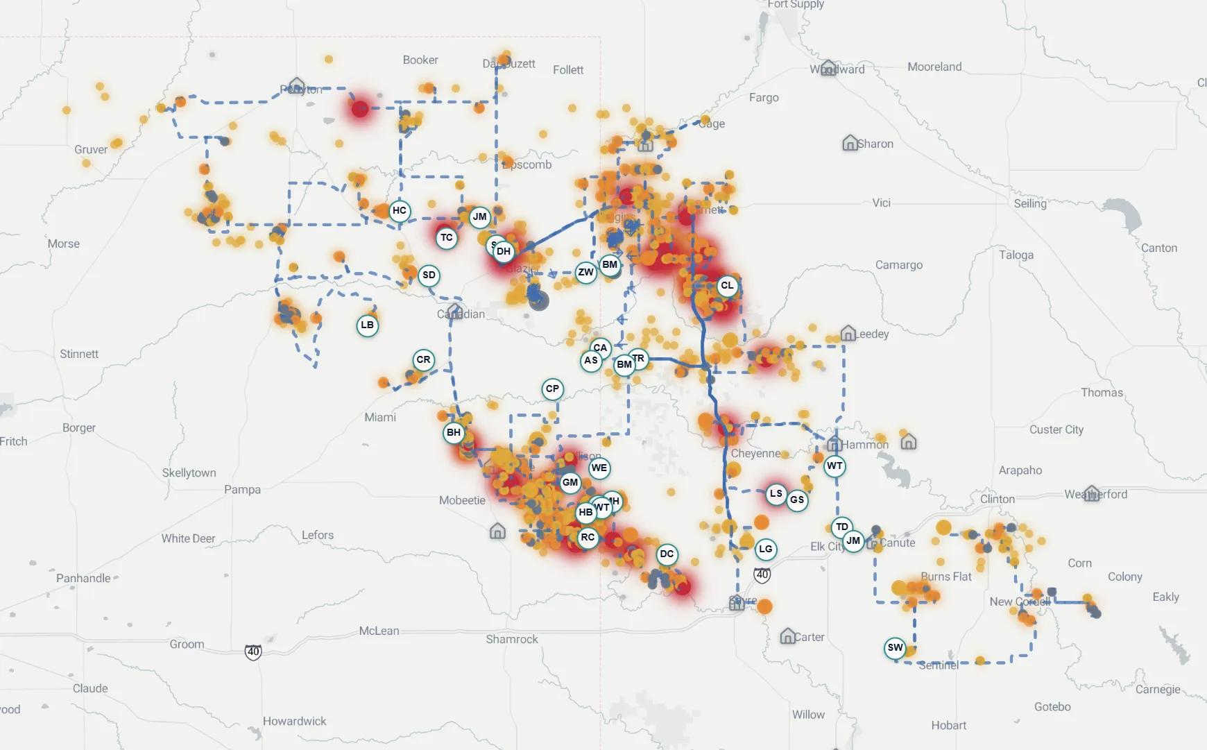
The operator-level playbook is on lease operator and pumper routes; the modeled dollar gap for your own field is on the route economics calculator.
Route planning and dispatch, common questions
What is route planning software for oil and gas?
It builds the daily driving and work plan for pumpers, lease operators, and field technicians: which wells to visit, in what order, by which crew. It differs from delivery routing in objective and in constraints. Oilfield stops differ in economic value by orders of magnitude on the same morning, and the plan has to respect crew qualifications, hours of service, lease-road access, escort requirements, and equipment that must arrive at the same place at the same time. The objective is value captured per crew-day, not distance.
How is routing software for oil and gas different from delivery routing?
Delivery routing minimizes distance because every package is worth roughly the same, so the cheapest tour of the stop list is the best answer. In the oilfield the stop list itself is the decision: a failing pump on a high-rate producer and a routine gauge on a stripper well are not equivalent stops. Horizontal fleet-routing platforms verticalizing into energy tend to keep the delivery objective and add oilfield fields on top, which optimizes the order of the wrong list.
What is oil and gas dispatch software?
Dispatch software decides who works what, when, and in what order, then gets that assignment to the crew. Upstream, that has historically been a superintendent with a whiteboard and a phone, allocating people by geography and by memory. Software-assisted dispatch replaces the geographic allocation with an economic one: work generated from field signals, priced by cash flow at risk, checked against qualifications and hours, sequenced into routes, and pushed to mobile before the shift starts.
Why does dispatching by geography fail on a producing field?
Geography is the right allocator when every stop is worth the same and travel is the dominant cost. On a producing field the dominant cost is deferred production on the wells nobody got to. Dispatch-by-area sends the nearest crew to the nearest work, which reliably fills a day with cheap stops while the well that started failing overnight waits for its scheduled visit.
Can field service dispatch software built for service companies work for operators?
It can carry real weight, and the scheduling and mobile workflows in that category are mature. The structural gap sits upstream of dispatch. Those platforms are built around tickets a customer opened and a job that bills. An operator is its own customer: nothing opens the ticket and no stop bills. Without a layer that generates and prices candidate work from production signals, the dispatch board is only as good as the list a human typed into it.
How does oilfield route optimization software handle crew qualifications and safety?
Properly implemented, they are hard constraints inside the solver rather than fields checked after the fact. H2S-certified crews are routed to sour wells, pressure-vessel inspectors to PV assets, and stops requiring an escort are scheduled as a synchronization join across two crew calendars. The safety result is fewer lone-worker exposures: across 5,000+ wells in live deployments, recordable incident rate moved from 1.8 to 0.3 (deployment figure).
What results should an operator expect from value-ranked routing?
Measured across 5,000+ wells in live deployments: 35% fewer miles driven at equal economic coverage and 15% free cash flow uplift on the same crew (deployment figures). The tank and deferral figures that follow from the same ranked plan are on the numbers page, each with its methodology. The mechanism behind every one is the same: crews stop driving to stops that earn nothing today.
How long does route planning software take to stand up?
The WorkSync stand-up is four weeks, read-only, against the systems of record you already own: telematics and qualification data in week one, the optimization engine and your economics in week two, crews trained and running on mobile in weeks three and four. Fit-for-purpose. Plug-and-play. The pilot is signed against one operating metric and your own baseline under the Impact Guarantee: we charge when your number moves.
Are your best people working on your most valuable work today?
See tomorrow's routes built on your own wells.
One operating metric, your own baseline, and we charge when your number moves.
Continue the cluster: Route Optimizer module · Lease Operator Routes · Route Economics · Research White Paper